

EU Research Project

This project has received funding from the European Union’s Seventh Framework Programme for research, technological development and demonstration under grant agreement no. 266470
Scientific contact
Max Planck Institute for Biological Cybernetics
 heinrich.buelthoff[at]tuebingen.mpg.de
Newsletters
 Newsletter #1, September 2011
Newsletter #2, March 2012
Newsletter #3, November 2012
Newsletter #4, August 2013
Newsletter #5, August 2014
Newsletter #6, March 2015
Newsletter #1, September 2011
Newsletter #2, March 2012
Newsletter #3, November 2012
Newsletter #4, August 2013
Newsletter #5, August 2014
Newsletter #6, March 2015

MS Wissenschaft 2015
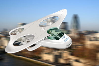
myCopter - Enabling Technologies for Personal Aerial Transportation Systems
The existing problem of traffic congestion combined with its anticipated growth presents a major challenge for future societal mobility and economic growth. A promising solution that combines the best of air- and ground-based transportation to overcome these problems is to establish a personal aerial transportation system (PATS) based on Personal Aerial Vehicles (PAV).
The myCopter project is a unique integration of social investigation and technological advancement to establish candidate enabling technologies for a PATS. Experts from across Europe have developed advanced technologies for automation, handling qualities and human-machine interfaces for PAVs, and have performed socio-technological evaluations to assess the impact of a PATS on society. The outcomes of this project provide a stepping stone for future endeavours aimed at moving personal transportation into the air.
The myCopter project is a unique integration of social investigation and technological advancement to establish candidate enabling technologies for a PATS. Experts from across Europe have developed advanced technologies for automation, handling qualities and human-machine interfaces for PAVs, and have performed socio-technological evaluations to assess the impact of a PATS on society. The outcomes of this project provide a stepping stone for future endeavours aimed at moving personal transportation into the air.
Making personal aerial vehicles a reality
The myCopter project has demonstrated that a personal aerial transportation system can become a reality, given appropriate technological advancements and socio-technological considerations. Innovations in vehicle automation, control augmentation and display interfaces have enabled pilots with extremely limited flight experience to safely operate a simulated personal aerial vehicle (PAV). Nonetheless, continued efforts are required to make a PATS that can be used by the general public a reality.
The outcomes of the myCopter project identify the next steps towards a PATS. The focus should be on development of real-world implementations of the automation and augmentation technologies required to bridge the skills gap between a highly-trained pilot and the average car driver. Just as importantly, several key socio-technological issues need to be addressed, including the legal and certification issues surrounding PAV automation and operation.
The outcomes of the myCopter project identify the next steps towards a PATS. The focus should be on development of real-world implementations of the automation and augmentation technologies required to bridge the skills gap between a highly-trained pilot and the average car driver. Just as importantly, several key socio-technological issues need to be addressed, including the legal and certification issues surrounding PAV automation and operation.
Exploring the socio-technological environment
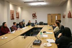
We have performed explorative investigations into the socio-technological prerequisites and implications of a personal aerial transportation system. Four focus group interview performed in different European countries have shed light on social expectation towards such a system and its potential role for future mobility.
We found that opinions amongst potential users regarding suitable levels of automation varied and mainly depended on the purpose of the journey. For commuting, a fully autonomous mode was regarded as desirable. However, several fundamental questions remain that relate to technical issues such as energy supply and noise pollution. From the user's perspective, the integration of PAV traffic into the existing transport infrastructures and architecture of European cities will need to be investigated in more detail since existing data are sparse and case-specific.
We found that opinions amongst potential users regarding suitable levels of automation varied and mainly depended on the purpose of the journey. For commuting, a fully autonomous mode was regarded as desirable. However, several fundamental questions remain that relate to technical issues such as energy supply and noise pollution. From the user's perspective, the integration of PAV traffic into the existing transport infrastructures and architecture of European cities will need to be investigated in more detail since existing data are sparse and case-specific.
Piloting personal aerial vehicles
We have developed a generic PAV flight dynamics model to simulate a range of tasks during a commuting scenario. Assessments using this model have shown that conventional rotorcraft response types are unsuitable for typical PAV pilots, but that augmented response types consistently allow both experienced pilots and flight naïve pilots to achieve very high levels of performance across a range of flight tasks with moderate workload.
We have also determined the skills required of a PAV pilot to safely operate the vehicle and have developed as appropriate training programme. Our programme was effective in developing the skills required to sly a series of PAV-mission related tasks in a flight simulator.
We have also determined the skills required of a PAV pilot to safely operate the vehicle and have developed as appropriate training programme. Our programme was effective in developing the skills required to sly a series of PAV-mission related tasks in a flight simulator.
Multi-sensory human-machine interfaces
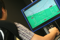
To make flying a PAV as easy as driving a car, it is necessary to develop human-machine interfaces (HMI) that are intuitive and sensitive to human competencies. We have developed novel multi-sensory HMIs by combining highway-in-the-sky displays with haptic control guidance. These have been used to investigate how pilots respond to guidance forces from various haptic algorithms.
We have also evaluated the human factors associated with PAV flight (e.g., cognitive workload) by employing non-obtrusive real-time methods such as gaze tracking, electro-dermal responses, heart-based measures and electro-encephalography (EEG) to estimate the perceived difficulty of a control tasks.
We have also evaluated the human factors associated with PAV flight (e.g., cognitive workload) by employing non-obtrusive real-time methods such as gaze tracking, electro-dermal responses, heart-based measures and electro-encephalography (EEG) to estimate the perceived difficulty of a control tasks.
Vision-based automation
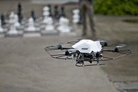
We have demonstrated the capability of autonomous flight in environments where accurate GPS-based localisation cannon be guaranteed, such as in urban environments. Our approach uses navigation loop consisting of monocular vision-based localisation and a state estimation framework.
The framework estimates the main vehicle states such as position, velocity and attitude, as well as intra- and inter-sensor calibration states, gravity alignment, and the visual scale that results from monocular vision. We have also proposed a resource-efficient control scheme for position and trajectory control that takes availability of visual features into account.
The framework estimates the main vehicle states such as position, velocity and attitude, as well as intra- and inter-sensor calibration states, gravity alignment, and the visual scale that results from monocular vision. We have also proposed a resource-efficient control scheme for position and trajectory control that takes availability of visual features into account.
Automatic collision avoidance and navigation

When many PAVs share the same airspace, a reactive strategy is required to ensure collision-free navigation. We have developed collision avoidance strategies inspired by human crowd behaviour that are able to ensure collision-free navigation and that take passenger comfort into consideration. Not only did we show that in simulation our approach is suitable for environments with up to 140 PAVs per cubic kilometre (more than 3 times originally planned) but also that our approach can be implemented in real-time conditions on unmanned flying vehicles.
We also studied solutions for automatic navigation by means of video data. We targeted three navigation tasks: 1) automatic detection of collisions course and general flight patterns, 2) automatic landing place assessment in man-made environments, and 3) automatic geographic localisation in large environments. We have developed novel computer visions methods that take into account geometry, temporal changes and appearance of the environment gathered from image data. Our techniques are focused on efficiency for on-board deployment. Combined, these methods provide a new set of algorithms that bring intelligent assistance for manned and unmanned aircraft navigation.
We also studied solutions for automatic navigation by means of video data. We targeted three navigation tasks: 1) automatic detection of collisions course and general flight patterns, 2) automatic landing place assessment in man-made environments, and 3) automatic geographic localisation in large environments. We have developed novel computer visions methods that take into account geometry, temporal changes and appearance of the environment gathered from image data. Our techniques are focused on efficiency for on-board deployment. Combined, these methods provide a new set of algorithms that bring intelligent assistance for manned and unmanned aircraft navigation.
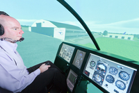
In-flight evaluations
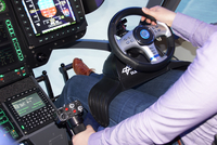
We have used ground-based and in-flight simulations to verify selected technological approaches developed within the myCopter project. Investigations into human-machine interfaces suitable for use in PAVs led to extending a conventional EC135 helicopter cockpit, which now features conventional controls, two active side-sticks, and steering wheel control for experiments with car-like steering concepts.
Selected technologies, such as a steering wheel prototype and highway-in-the-sky display, are being demonstrated in flight on DLR's EC35 Flying Helicopter Simulator, which used model-based control technology to implement typical PAV flight characteristics.
Selected technologies, such as a steering wheel prototype and highway-in-the-sky display, are being demonstrated in flight on DLR's EC35 Flying Helicopter Simulator, which used model-based control technology to implement typical PAV flight characteristics.